Skip to content
Mapping Technology in Public Safety

Mapping Technology in Public Safety

Sharing technology information from a responder perspective

Home  >  
July 28, 2013

Presentation from the ESRI Homeland Security Conference 2012

http://proceedings.esri.com/library/userconf/hss12/videos/lt-fdny-lg.html

Categories Cool Things to Read
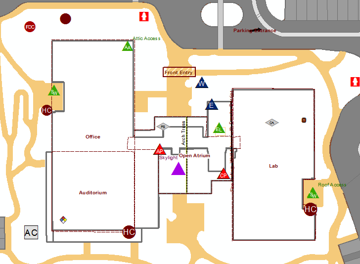
March 13, 2013

New Video about using the Incident Symbology Guideline

I just created a new video describing how to use the guidelines created by the NAPSG Incident Symbology Workgroup.  Take a look and leave a comment below.

Categories Cool Things to Read

RSS Mapping Tech Podcasts

  • Oregon Emergency Management
  • What could we have done differently?
  • Public Safety Communications Research 2020 Conference Review
  • ESRI GIS User Conference - Finale Wrap Up
  • ESRI GIS User Conference - Day 3 Wrap Up
  • ESRI GIS User Conference - Day 2 Wrap Up
  • ESRI GIS User Conference - Day 1 Wrap Up
  • Play the Long Game - Houston PD GIS
  • Mapping Tech in Public Safety - GIS Corps
  • Mapping Tech in Public Safety - Still at Home

Pages

  • Chris Rogers
  • David Blankinship
  • Peter Hanna
  • Steve Pollackov
  • Map Gallery

Categories

  • Cool Things to Read
  • For Everyone
  • For Responder
  • For Technical Users
  • Geography for Firefighters
  • Podcast
  • Preplan Tips
  • Tips for GIS
  • Uncategorized

Admin

  • Log in
  • Entries feed
  • Comments feed
  • WordPress.org

©2023 Mapping Technology in Public Safety

  • Youtube
  • Slack
Back To Top